Table of contents (11 sections)
AI Face Recognition and Satellites: High-Tech Panda Protection
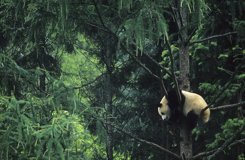
Key Fact: When a camera trap in the Minshan Mountains photographs a wild panda at midnight, a researcher needs to know one thing: is this a new panda, or one we have seen before? Answering that question for thousands of images used to take months of human analysis — comparing each photograph against every known individual in the database. Today, an AI system at the Chengdu Research Base performs the same task in seconds, identifying individual pandas by their unique eye patch patterns with over 93% accuracy. This is the intersection of machine learning and conservation biology — and it is transforming how we know what we know about wild pandas.
Key Takeaways
-
AI identifies pandas by eye patch patterns — the same way humans use fingerprints — achieving 93% accuracy under optimal conditions.
-
The AI pipeline processes millions of camera trap images in hours rather than months, transforming the speed of conservation monitoring.
-
AI amplifies human research capacity — it does not replace it. The system handles the volume; humans handle the judgment.
Why Pandas Are Difficult to Identify
The problem that AI panda recognition solves is not obvious until you try to solve it manually. Unlike tigers, whose stripe patterns are distinct and stable, or whale sharks, whose spot patterns create unique constellations, pandas present a recognition challenge:
Fur similarity. All giant pandas share the same black-and-white color pattern. The eye patches, while individually distinctive, vary within a much narrower range than tiger stripes or human fingerprints. The variation is there — but it is subtle.
Illumination variation. Camera trap images are captured at all hours, in all weather conditions, in dappled forest light and infrared darkness. The same panda photographed at noon and midnight can look like two different individuals to a computer vision system.
Pose variation. A panda photographed from the front, from the side, with its head tilted, or partially obscured by bamboo presents different feature geometry. The AI system must learn to recognize the same panda across all these possible poses.
Age-related changes. A panda cub’s facial features change visibly over its first 18 months. A panda photographed as a juvenile must be re-identifiable as an adult years later — despite significant changes in facial proportion.
The Eye Patch Fingerprint
The AI system at the Chengdu Research Base exploits a biological feature that is as individually distinctive as a human fingerprint: the shape, size, and orientation of the black eye patches that surround a panda’s eyes.
Each panda’s eye patches differ in:
- Overall size and proportion relative to the face
- Shape of the lower edge — the curve where the black meets the white
- Inner corner angle — the angle at which the patch meets the bridge of the nose
- Vertical position — how far the patch extends above and below the eye
- Minor irregularities — notches, extensions, asymmetry between left and right
These features, combined, create a unique facial signature. The variation is subtle enough that human observers struggle to articulate it — but sufficient for a properly trained neural network to distinguish individuals with high reliability.
The AI Pipeline
The system processes each camera trap image through a structured pipeline:
| Stage | Step | What Happens | Output | Typical Processing Time |
|---|---|---|---|---|
| 1 | Image acquisition | Camera trap fires; RAW image captured | Unprocessed image | Real-time (camera) |
| 2 | Detection | AI scans image for panda faces using object detection model | Bounding box around face | 100-200 ms |
| 3 | Segmentation | Eye patch regions isolated from face crop | Normalized patch images | 50-100 ms |
| 4 | Feature extraction | CNN extracts feature vector (embedding) — a mathematical representation of patch geometry | 128-512 dimensional vector | 50-100 ms |
| 5 | Identity matching | Embedding compared against database of known panda embeddings | Ranked list of candidate matches | 10-50 ms |
| 6 | Verification | Top candidate match reviewed against confidence threshold | Identity label (or “unknown” if below threshold) | Instant |
The entire pipeline — from raw image to identity — completes in under half a second. From a batch of 10,000 camera trap images, the system can identify all pandas present and flag unknown individuals for human review within minutes.
Accuracy Depends on Conditions
AI panda recognition accuracy is not uniform — it varies significantly with image conditions. Understanding these variations is essential for interpreting the system’s results.
| Condition | Typical Accuracy | Why | Recommended Confidence Threshold |
|---|---|---|---|
| Front-facing, good daylight | 93-96% | Maximum feature visibility | 0.90 |
| Side profile, daylight | 80-85% | Reduced eye patch feature area | 0.85 |
| Nighttime, infrared | 75-82% | Lower contrast, IR artifacts | 0.80 |
| Partial occlusion (bamboo) | 70-78% | Key features obscured | 0.75 |
| Heavy occlusion (face partially hidden) | 55-65% | Insufficient feature information | 0.70 |
| Cub (<12 months) | 65-75% | Rapidly changing facial features | 0.70 |
| Wet fur (rain) | 78-85% | Altered fur texture and patch boundaries | 0.80 |
| Snow-covered | 72-80% | Reduced contrast, white-on-white challenge | 0.75 |
In operational deployment, the system flags any identification with confidence below the recommended threshold for human verification. This hybrid approach — AI pre-screening with human verification for uncertain cases — achieves an effective accuracy of 95%+ on the combined workflow.
Beyond Faces: The Future of Panda Recognition
Current AI panda recognition relies almost exclusively on eye patch analysis. The next generation of systems will incorporate multiple additional identification modalities:
Body pattern analysis. Subtle variations in the black shoulder band pattern, fur whorls, and the transition zone between black and white on the torso provide supplementary identification features.
Fur texture analysis. High-resolution images capture subtle differences in fur texture and density that are characteristic of individuals. This modality requires close-up images not yet available from standard camera traps.
Gait analysis. The way a panda walks — stride length, limb angles, head position — is individually distinctive. Gait recognition would allow identification from video footage at distances where facial features are not resolvable.
3D facial reconstruction. Combining multiple camera angles to create a three-dimensional model of a panda’s face provides richer identification features than 2D images alone. This approach is being tested at Chengdu Base with multi-camera arrays installed in enclosure passageways.
Multimodal fusion. The ultimate system will combine visual recognition with non-image data — scent mark chemical profiles, vocalization analysis, and GPS collar location patterns — to create a multi-factor identification that is more robust than any single modality.
Panda vs Other Wildlife AI Systems
| Species | Recognition Feature | Published Accuracy | Key Challenge | System Scale |
|---|---|---|---|---|
| Giant Panda | Eye patch pattern | 93% | Black-and-white reduces feature contrast; pose variation | Facility-level + pilot wild deployment |
| Tiger | Stripe pattern | 95-97% | Requires clear flank images; left/right sides differ | National-level (India) |
| African Elephant | Ear notch pattern, tusk shape | 90-95% | Ears change with age; tusks break | Reserve-level |
| Whale Shark | Spot pattern | 97%+ | Most distinctive individual pattern of any species | Global database |
| Snow Leopard | Spot/rosette pattern | 90-92% | Low population density; limited training images | Regional |
| Brown Bear | N/A (limited AI use) | ~80% | Fur uniformity; limited identification features | Experimental |
Panda recognition sits in the middle of the wildlife AI accuracy spectrum — more challenging than whale sharks (whose spot patterns are the most distinctive in the animal kingdom) but more reliable than brown bears (whose uniform fur provides few identification features). The primary limitation for pandas is not technical but practical: the eye patch features, while sufficient for reliable identification, have less individual variation than stripe or spot patterns.
Real Deployment Case: Chengdu Research Base
The most advanced deployment of AI panda recognition is at the Chengdu Research Base of Giant Panda Breeding, where the system processes images from the base’s camera trap network and operates as an enclosure monitoring tool simultaneously.
The system was trained on 10,000+ labeled images of approximately 80 known pandas at the base. Training required approximately 200 GPU-hours on NVIDIA Tesla V100 hardware. The trained model, after optimization for edge deployment, runs on a standard workstation.
Deployment results over a 12-month evaluation period:
- 2.3 million camera trap images processed
- 47,000 panda detections (2% of total images contained pandas)
- 93.4% automated identification accuracy (within system confidence threshold)
- 12% of identifications required human verification (below confidence threshold)
- 0.3% false positive rate (incorrect identity assignment)
The system is now being expanded to support wild panda identification in the Giant Panda National Park, where the camera trap network described in our article on infrared monitoring generates millions of images annually.
Could AI Replace Human Researchers?
The question arises with every AI deployment in conservation: does the technology replace the people who do this work?
The short answer is no. AI replaces tasks, not roles. The AI system processes images at a speed no human could match — but it cannot:
- Interpret behavioral context from images (is this panda stressed? injured? in estrus?)
- Handle novel situations that the training data did not cover
- Make ethical judgments about intervention
- Build the relationships with local communities that make conservation possible
- Trek through snow to replace camera trap batteries
The rangers who maintain the camera network — described in our article on the human network behind the cameras — remain essential. The AI makes their data more useful. It does not replace their boots on the ground.
Frequently Asked Questions
Can AI identify individual pandas in group photos?
Yes — the system can detect and identify multiple pandas in a single image. However, occlusion (one panda blocking another) reduces accuracy for the partially obscured individual. The system processes each detected face independently.
How many images are needed to train the AI system?
The Chengdu system was trained on 10,000+ labeled images of known individuals. A new panda added to the system requires approximately 50-100 images from multiple angles for reliable identification. Fewer images result in higher uncertainty and more frequent human verification requirements.
Does the AI system improve over time?
Yes — the system uses a semi-supervised learning approach. When human reviewers verify or correct the system’s identifications, the corrected data is fed back into the training pipeline. The system’s accuracy on subsequent images of the same panda improves incrementally with each correction.
Can the AI system run on a smartphone?
A lightweight version of the detection model — sufficient for real-time panda face detection but not full identification — has been optimized for mobile deployment. The full identification pipeline requires more computational resources than current smartphones can provide, but mobile-optimized models are in development.
How does the system handle pandas that have never been seen before?
Images that cannot be matched to any known panda at sufficient confidence are flagged as “potential new individual.” These are reviewed by human researchers. If confirmed as a new panda — or a known panda not yet in the database — the image is used to create or update the individual’s embedding profile. This is how the system identifies newborn cubs and new wild individuals.
Your Turn
The AI system at Chengdu processes its millionth image. The panda in the photograph — photographed by a camera trap in the Minshan range, identified in under a second, matched against a database of hundreds of known individuals — is a number in a database. But the technology behind that identification represents years of research, training, and validation. Read our article on camera trap monitoring and the rangers who maintain the network to see the full pipeline from field to database, and our data methodology page to understand how every piece of panda data — whether identified by AI or by human — is verified before it reaches this site.

Dr. Mei Zhang
Spatial Ecology & Conservation Editor
Spatial ecologist using GIS, remote sensing, and satellite imagery to study panda population dynamics, habitat connectivity, and conservation effectiveness at landscape scales.
View full profile →Tags in this article
Questions readers often ask
How does AI panda recognition work?
AI panda recognition uses convolutional neural networks (CNNs) trained on thousands of labeled panda photographs. The system first detects the panda's face in an image, segments the eye patch region, extracts distinctive features (shape, size, orientation of the black eye patches), generates a mathematical embedding vector, and matches it against a database of known individuals. The entire pipeline — from raw image to identity — takes under a second.
How accurate is AI panda recognition?
The leading system, developed at the Chengdu Research Base, achieves over 93% accuracy under optimal conditions — front-facing images with good lighting. Accuracy decreases to approximately 75-80% for side-profile images, nighttime infrared photos, and images where the face is partially obscured by bamboo or fur. Accuracy is lowest (below 70%) for cubs, whose facial features change rapidly during growth.
How does panda AI recognition compare to other species?
Panda recognition accuracy (93%) is comparable to tiger stripe recognition (95%+) and African elephant ear-pattern recognition (90%+). It is lower than whale shark spot-pattern recognition (97%+) because panda faces have less distinctive individual variation than whale shark spot patterns. Panda recognition faces additional challenges: the black-and-white fur reduces contrast in feature boundaries, and the eye patches — the primary recognition feature — change shape with facial expression and angle.
Can the AI system identify wild pandas from camera trap images?
Yes — this is the primary deployment use case. Camera trap images of wild pandas, previously analyzed by human reviewers over months, are now processed by the AI system in hours. The system pre-sorts the data, flags panda images for human verification, and attempts to match each detected panda against the known identity database. This has enabled the first large-scale studies of wild panda movement patterns based on re-identification across camera trap locations.
Can AI identify panda cubs?
Cub identification is more challenging than adult identification because facial features change rapidly during the first 12-18 months. The eye patch shape, which is the primary recognition feature in adults, is still developing in cubs. Current systems require more frequent retraining for cub identification and achieve lower accuracy (approximately 70-80%) compared to adult identification.
Can twins confuse the AI recognition system?
Twin pandas that share similar facial features can indeed be confused by the AI system. The Chengdu Research Base system has documented higher false-matching rates between twin pairs than between unrelated individuals. However, twins are typically distinguishable by trained human observers, and the AI system's accuracy on twins (approximately 80-85%) still exceeds random assignment (50% for a pair). Combining AI recognition with studbook records and enclosure location data resolves most twin identity questions.
Does fur molting or seasonal changes affect recognition accuracy?
Seasonal fur condition changes — particularly the thinner summer coat and thicker winter coat — can alter the apparent shape of the eye patches and reduce recognition accuracy by approximately 5-10%. The AI system is trained on images from multiple seasons to mitigate this effect. Fur discoloration from age or health conditions presents a more significant challenge but affects relatively few individuals.
Could AI eventually replace human panda researchers?
No — AI is a tool that amplifies human research capacity, not a replacement. The AI system processes images at a speed no human could match, but it still requires human oversight for verification, for handling edge cases (unusual poses, poor lighting, infants), and for interpreting behavioral data from the images it identifies. The rangers and researchers described in our article on infrared camera monitoring remain essential — the AI simply makes their work faster.